Animated travel maps, made in your browser.
Draw your route or drop in a GPX file, choose how you travelled, pick a map style and export an MP4 for YouTube, Reels or TikTok. Free, with no account, and the video is rendered on your own computer.
Greek island hopping
Ferry · Mediterranean style · 16:9
- Athens (Piraeus)Start
- Mykonos160 km
- Paros200 km
- Naxos220 km
- Santorini300 km
- Heraklion420 km
- No account, no watermark
- MP4 up to 4K at 60 fps
- GPX, KML, KMZ, IGC
- Nothing is uploaded
From a route to a video in four moves.
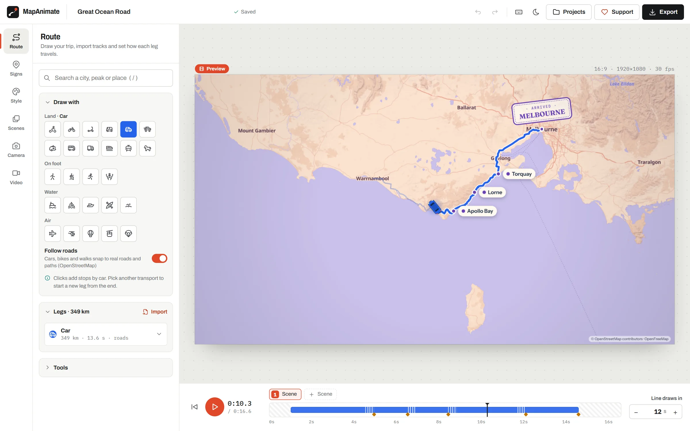
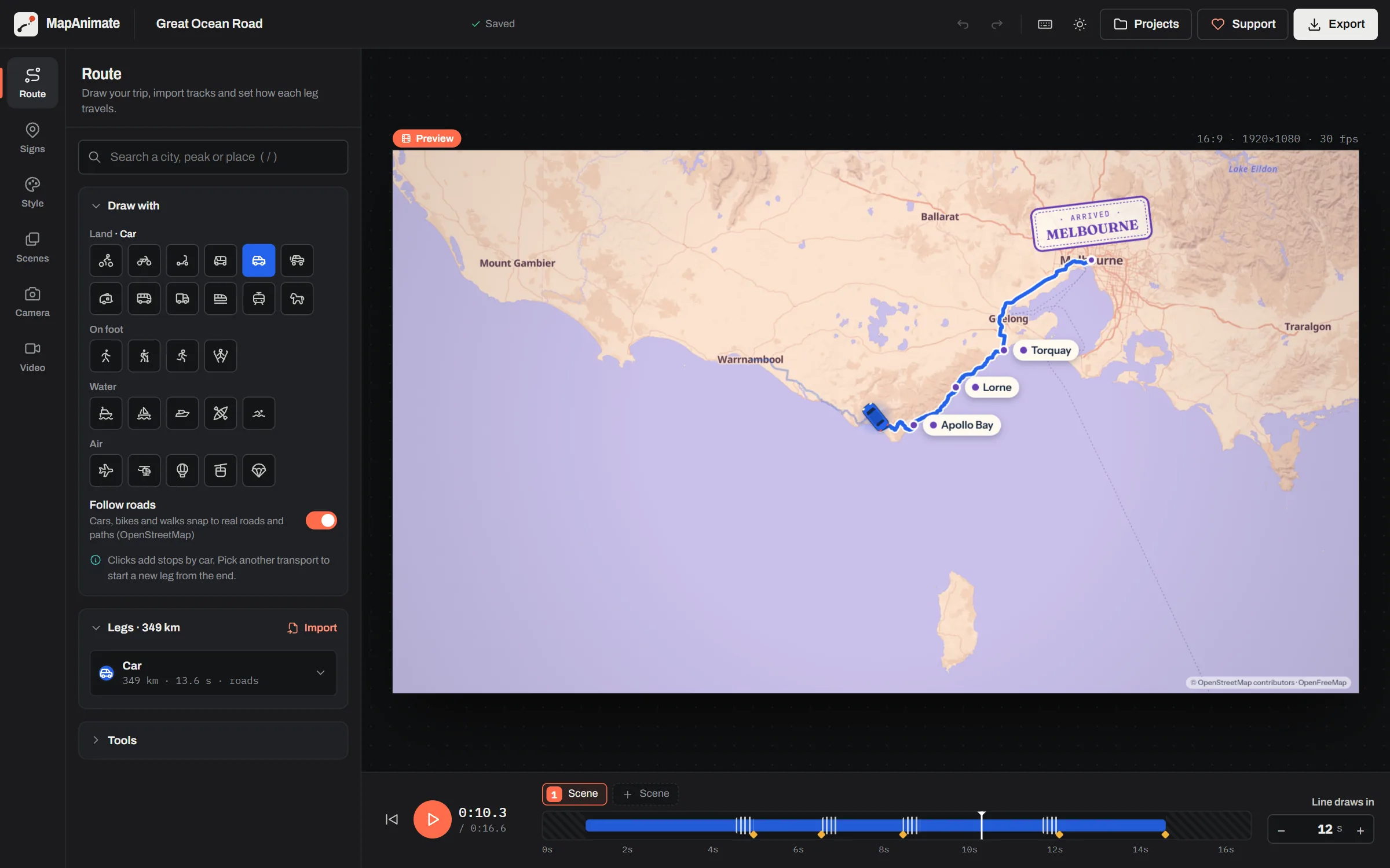
The preview plays exactly like the export, frame for frame, so what you see while editing is what you get.
-
Draw
Click stops on the map, search for places, or import a GPX, KML, KMZ or IGC track.
26 ways to travel -
Style
Pick a map style, a layout for titles and labels, then add signs, stamps and photos.
16 styles · 3D globe -
Frame
Follow the marker, glide between two shots, hold a fixed frame or show the whole trip.
4 camera modes · 20 scenes -
Export
Render an MP4 with your music and voice-over, a transparent WebM, or a GIF.
up to 3840×2160 · 60 fps
One trip, every screen.
Switch the frame between 16:9, 9:16, 1:1 and 4:5 and the camera reframes itself. Both videos here are untouched exports.
- 16:9
- YouTube, presentations, travel vlogs
- 9:16
- Reels, TikTok, Shorts, Stories
- 1:1 and 4:5
- Instagram and Facebook feeds
The same trip in 16 map styles.
Each image below is a frame from the editor, not an illustration. Switching style changes nothing else in your project.
 MediterraneanSun-baked terracotta land and deep azure sea
 Field NotesWarm cream paper with soft greens and quiet roads
 SatelliteCloud-free Sentinel-2 imagery of the whole planet
 MidnightDeep navy land, inky seas and softly glowing roads
 Old AtlasAged parchment, sepia ink and a sea of faded jade
 TopographicHiker's map with strong relief and leafy greens
 Neon NightBlack streets and electric magenta and cyan
 WatercolourSoft painted washes on white paper
What's in the editor
Everything here is free today. The changelog lists what changed and when.
- Draw
- Click stops on the map or search for a place. Car, bike and walking legs can follow real roads and paths from OpenStreetMap.
- Import
- GPX, KML, KMZ and IGC from Garmin, Strava, Komoot, Google My Maps or a flight instrument. Long tracks simplify with one slider.
- Travel
- 26 ways to travel, each with its own line and animated vehicle: planes climb and leave a contrail, trains pull carriages, boats leave a wake.
- Look
- 16 map styles from journal paper to satellite, 3D mountains, and a 3D globe for trips that cross oceans.
- Story
- Up to 20 scenes with fly, fade or cut transitions, title cards, signs, passport stamps and your own photos.
- Sound
- Your music, a voice-over you record in the browser, and sound effects for each way of travel.
- Export
- MP4 at 1080p, 1440p or 4K, 24–60 fps. Also a transparent WebM for your own footage, and GIF.
Legend
Every leg of a trip has its own line. Flights arc along the great circle, walks are dotted, rail gets a track.
Start from a famous route
Each one opens in the editor with its stops, transports and a map style. Change it to match your own trip.
-
Route 66
Road trip
~3,114 km -
Trans-Siberian Railway
Rail journey
~7,191 km -
Camino de Santiago (Camino Francés)
Pilgrimage walk
~641 km -
Iceland Ring Road
Road trip
~956 km -
Pacific Coast Highway
Road trip
~782 km -
Interrail: Paris to Budapest
Rail journey
~1,752 km -
Banana Pancake Trail
Backpacking loop
~3,364 km -
Round-the-World Flights
Flight itinerary
~40,053 km
Questions
Is MapAnimate free?
Yes. MapAnimate is completely free, with no account, no watermark, no paywall and no export limits. It is funded by donations and, in the future, by clearly labelled sponsors on the website (never inside your videos).
Do I need to create an account?
No. Open the editor and start. Your projects are saved automatically in your own browser, and you can download a project file to move it to another computer or keep a backup.
Can I use the videos commercially, for example on a monetised YouTube channel?
Yes. You can use the videos in personal, monetised and commercial work. The map data comes from OpenStreetMap, so keep the small map credit that is drawn in the corner of every video.
Is there a watermark?
No. MapAnimate never adds its logo to your video. The only text added automatically is the small map data credit required by OpenStreetMap and the tile providers.
What video formats and sizes can I export?
MP4 (H.264) at 1080p, 1440p or 4K, at 24, 30 or 60 frames per second, in 16:9 landscape (YouTube), 9:16 vertical (Reels, Shorts, TikTok), 1:1 square and 4:5 portrait. You can also export a transparent WebM (the route and titles without the map, to layer over your own footage) or a GIF.
Free, and paid for by the people who use it.
There are no ads in your videos and nothing to upgrade to. Donations pay for map hosting and for new features such as more map styles and vehicles.
- AccountNone needed
- WatermarkNever
- Where your projects liveIn your browser
- Where the video is madeOn your computer
- Sponsors appearOn this website only